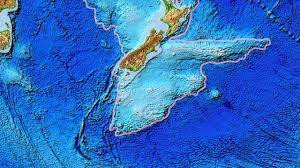
In a remarkable geological revelation, Zealandia, Earth’s elusive 8th continent, has emerged from the depths of the sea. Geologists have meticulously mapped this submerged landmass, encompassing a sprawling two million square miles, shedding light on its extraordinary geological history.
Approximately 83 million years ago, the colossal supercontinent Gondwana underwent a dramatic split, a pivotal event that led to the formation of the continents we recognize today. This monumental process gave birth to Zealandia, which remained shrouded beneath the ocean’s surface, with only 6% protruding to form New Zealand and its neighboring islands.
The relative obscurity of Zealandia, concealed beneath the ocean’s depths, had left its form and structure largely uncharted. To unravel this geological enigma, an international team of geologists and seismologists embarked on a groundbreaking journey, enhancing existing maps of Zealandia through meticulous analysis of rock and sediment samples collected from the ocean floor and coastal islands.
Augmented by the insights gained from seismic data analysis, this relentless pursuit yielded a refined, 5 million square kilometer map of Zealandia. This cartographic masterpiece unearthed geologic patterns hinting at the presence of a subduction zone adjacent to the Campbell Plateau off the west coast of New Zealand. Remarkably, magnetic anomalies, often associated with such regions, were conspicuously absent, challenging previous theories of strike-slip faults.
In a surprising twist, the researchers propose that the Campbell Magnetic Anomaly System, rather than being born from strike-slip faults, resulted from the stretching of Gondwana during its gradual separation, ultimately shaping Zealandia’s submerged oceanic regions.
Detailed chemical analysis and geological evidence further suggest that subduction of Zealandia’s edge occurred approximately 250 million years ago, beneath what is now the Campbell Plateau. Subduction, a geological phenomenon, involves one crustal edge plunging beneath another into Earth’s mantle. Intriguingly, magnetic anomalies in this vicinity are unrelated to this particular event.
Challenging the conventional belief in the existence of a strike-slip ‘Campbell Fault,’ the researchers assert that Zealandia and Antarctica both underwent extensive internal deformation. They posit that the Campbell Magnetic Anomaly System emerged from the substantial stretching that transpired between segments of Gondwana, eventually shaping the seafloors surrounding Zealandia.
Around 83 million years ago, the confluence of Zealandia/West Antarctica and Antarctica/Australia led to a fracture, permitting the Tasman Sea to inundate the region. Subsequently, approximately 79 million years ago during the Late Cretaceous period, Zealandia and West Antarctica underwent separation, paving the way for the formation of the Pacific Ocean.
The distinctive thinning of Zealandia’s crust, akin to West Antarctica, has intrigued geologists for years. The researchers uncovered compelling evidence of variable stretching directions between 100 and 80 million years ago, offering a potential explanation for the significant thinning of the continental crust.
These groundbreaking findings not only unveil Zealandia’s geological past but also provide a robust foundation for further investigations into the intricate stretching of Earth’s crust in this region, inviting explorations into the hidden mysteries of our planet’s ever-evolving geological tapestry.